")
Pas de l'Ours
-
04 Via Ferrata Pas de l'Ours, Ugine, Savoie, France
Via Ferrata Pas de l'Ours et Golet de la Trouye, Ugine

Passerelle Pont de singe Echelle Tyrolienne 0 0 1 0 Caractéristiques
Il s’agit plus d’une course d’escalade, une randonnée sécurisée par une ligne de vie qu'une via ferrata classique selon le standard français. La via est intégrée à une randonnée menant au sommet du Mont Charvin. Les tronçons de câble sont parfois assez long: 10 m.
Les deux via ferrata ne sont pas connectées l’une à l’autre: La Via Ferrata du Pas de l’Ours et la Via Ferrata du Golet de la Trouye
 Conseils ViaFerrata
Il te faut impérativement un casque, d'excellentes chaussures de marche et une corde dans ton sac si tes collègues de randonnées sont sensibles au vide. C'est une randonnée équipée, mais pas toujours. Parfois glissant et dangereux.
Sens du circuit recommandé: Montée du Golet de la Trouye, Arrête Sud, Arrête Est, Via Ferrata du pas de l'Ours, Merdassier du Milieu
Cotation
Physique 1 Gaz 4 Type Haute-Montagne: 1 Technique 1 Evaluation Difficile Information
Office du Tourisme de Ugine
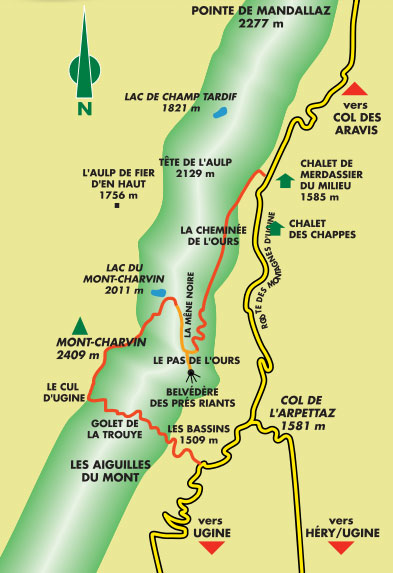
 Longueur & Altitudes
Départ Via Ferrata: 1'585 m
Sommet Via Ferrata Pas de l'Ours: 2'130 m
Dénivelé: 545 m
Longueur totale 250 m.Sommet Via Ferrata Golet de la Trouye: 2'410 m.
Coordonnée GPS du départ

Période
Du 15 juin au 15 octobre
Horaire
Via ferrata allez-retour: 5h00.
Approche: 1h00
Total de la journée: 5h-6hPar la route
Ugine se trouve à un jet de pierre d'Albertville
Par le TrainVoir avec la S.N.C.F .
 Accès
AccèsD'Ugine, prends la route qui mène au Col de l'Arpettaz, puis suivre la route carrossable des Montagnes
d’Ugine jusqu’au chalet de Merdassier du Milieu à 1585 m.Parking.
Du chalet de Merdassier du Milieu, on atteint le départ par un sentier longeant la crête qui relie la Tête de l’Aulp au Mont-Charvin en 1h30 environ.
Via Ferrata
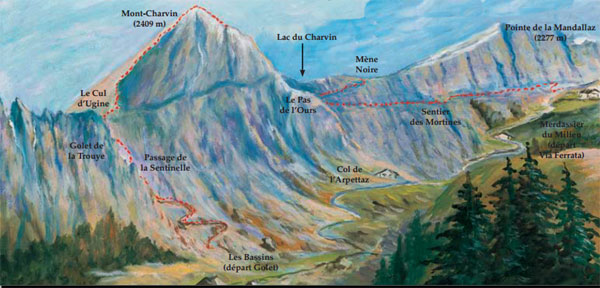
Passage naturel, la Mène Noire est une vire étroite entre une bande de schiste et de calcaire. La suivre sur 250 m grâce au parcours équipé de câbles qui débouche sur l’arête faîtière du Mont-Charvin où la vue se dégage sur les Alpes et où on domine la vallée de Manigod et tout près le lac du Charvin.
En remontant l’arête assez aérienne, tu parviens au sommet 2409 m, bordé au Sud par des parois rocheuses. Du sommet on jouit d’un magnifique
panorama sur l’ensemble des Alpes du Nord, ainsi que sur les Massifs du Mont-Blanc et du Beaufortain.Descendre par le même itinéraire.
Retour
Compte 1h.
Ou dormirVoir avec l'Office du Tourisme. Il y a un camping à proximité.
Photos
par Chaîne de zebrprod, Youtube
-
-
04 Via Ferrata Pas de l'Ours, Ugine, Savoie, France
Via Ferrata Pas de l'Ours et Golet de la Trouye, Ugine, Savoie
Footbridge Monkey Bridge Ladder Zipline 0 0 1 0 Features
It's more like a climbing route or a hike secured with a lifeline than a via ferrata in the classic sense according to French standards. The via is integrated with a hike that leads to the Mont Charvin summit. The sections of cable are sometimes fairly long: 10 m.
The two via ferratas are not connected to each other: The Pas de l'Ours Via Ferrata and the Golet de la Trouye Via Ferrata
ViaFerrata Tips and TricksIt is imperative that you have a helmet, good hiking shoes and a rope with you if your hiking colleagues are afraid of heights. It's an equipped hiking route, but not always. Sometimes its slippery and dangerous.
Recommended direction of travel: Golet de la Trouye climb, South Arrête, East Arrête, Pas de l'Ours Via Ferrata, Merdassier du Milieu
Grade
Strength 1 Dizziness 4 Type High Mountain: 1 Technics 1 Evaluation Difficult Information
Length & AltitudesVia Ferrata start: 1,585 m
Top of the Pas de l'Ours Via Ferrata: 2,130 m
Elevation gain: 545 m
Total length: 250 m.Top of the Golet de la Trouye Via Ferrata: 2,410 m.
Time of Year
15th of June to 15th of October
Timing
Via ferrata there and back: 5h00.
Approach: 1h00
Total for the day: 5h-6hBy Car
Ugine is found a stone's throw away from Albertville
By TrainCheck with the S.N.C.F .
AccessFrom Ugine take the road that leads to the Arpettaz pass and then follow the paved road from the mountains of Ugine to the Merdassier du Milieu chalet at 1585m.
Parking lot.
From the Merdassier de Mileu chalet you can reach the start via a trail that follows along the ridge which connects the Tête de l'Aulp to the Mont-Charvin in about 1h30.
Via Ferrata
A natural passage, the Mène Noire is a narrow ledge between a strip of schist and limestone. Follow it for 250m thanks to a route secured with cables that leads to the Mont-Charvin ridge. From here the view opens out onto the Alps and overlooks the Manigod valley and the Charvin lake nearby.
By climbing the fairly vertiginous ridge you get to the 2409m summit which is lined on the South with rocky cliffs. From the summit you can revel in the magnificent panorama of the entirety of the Northern Alps along with the Mont-Blanc and Beaufortain massifs.
Follow the same itinerary to go back down.
Way Back
Takes 1h.
Where to Spend the NightCheck with the Tourism Office. There is a camping nearby.
Media
par Chaîne de zebrprod, Youtube
-