")
Peisey
-
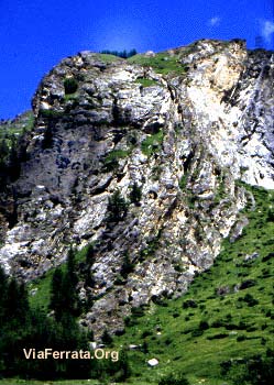
06 Via Ferrata les Bettières, Peisey Nancroix, Savoie, France
Via Ferrata les Bettières, Peisey Nancroix

Passerelle Pont de singe Echelle Tyrolienne 1 1 0 0 Caractéristiques
Trois niveaux différents en trois parties avec des échappatoires entre les trois parties.
Pour toute la famille.
Accès au départ de la ferrata très rapide. Pont népalais impressionnant, quelques passages techniques qui demandent beaucoup de bras et de courage avec une sortie en dévers. Possible de prendre les échappatoires. La dernière partie est réservée aux chevronnés. Conseils ViaFerrata
C’est la grande foule durant l’été ! Vas-y de bonne heure le matin !
Si tu as le temps, fais le tour du Mont Pourri: Mt Pourri, Aiguille du St-Esprit, Dôme de la Sache, Gr 5.Cotation
Physique L'Eperon des Croës: 1
Le Grand Pillier: 3
Le Sommet : 3Gaz L'Eperon des Croës : 2
Le Grand Pillier : 3
Le Sommet : 3Type Haute-Montagne: 2 Technique L'Eperon des Croës : 1
Le Grand Pillier : 1
Le Sommet : 1Evaluation L'Eperon des Croës : Peu difficile - Initiation
Le Grand Pillier : Difficile
Le Sommet : Très DifficileInformation
Office du Tourisme de Peysey-Vallandry
 Longueur & Altitudes
Départ Via-Ferrata: 1'556 m,
Arrivée Via-Ferrata 1'910 m.
Denivelé: 354 m
Longueur : 500 mCoordonnée GPS
Latitude : 45.518932
Longitude : 6.802318Période
Du 15 mai au 31 octobre
Horaire
l'Eperon des Croës
Accès ViaFerrata: 15 min
Via ferrata : 30 min
Retour : 20 minLe Grand Pillier
Via ferrata: 45 minutes
Retour : 30 minLa Sortie
Via ferrata : 20min
Retour : 50 minPar la routeRejoindre la vallée de la Tarentaise par l'autoroute Alberville, puis Moûtiers. Après Aime, prendre la direction de Landry. Monter les épingles dans la vallée de Peisey-Nancroix. Se garer en fond de vallée près du plan d'eau après le hameau des Lanches.
Par le TrainVoir avec la SNCF pour les bus et train.
 Accès
AccèsPanneau d'information et fléchage en début de ferrata.
Via Ferrata
1er tronçon : l'éperon des Croës accessible aux enfants (PD), échappatoire en fin de tronçon. *Approche : 15 min
2è tronçon : Il débute par une verticale d'environ 50 mètres. Suivie par une arrête exposée et, continuant par une seconde verticale, pour s'achever sur le pont népalais. Second échappatoire permettant une redescente dans la vallée. *Approche : 0min depuis le 1er tronçon3è tronçon : Grande dalle jaune surplombante plus sportive , retour par le plateau pour rattrapper le sentier "Les Lanches - Mont Pourri", ou par une sortie câblée à gauche qui descend directement dans la combe voisine et redescend en lacet. *Approche : 0min depuis le 2ème tronçon.
Cette dernière partie est très technique et difficile avec un dévers de 15 mètres. Il s'agit d'un surplomb impressionnant. Si tu n'as plus de force, prends l'échappatoire. La suite permet de rejoindre le sentier des Lanches – Le Mont Pourri.Retour
Le retour est de toute beauté. Prends à gauche au sommet de la via. Suis les câbles et une échelle. Un sentier pentu te conduit directement au parking.
Ou dormirRefuge du Mont PourriRefuge du Mont Pourri: 2'380 m, au lieu-dit La Savolière. Accès par les Lanches
Photos
par viaferrataalpes, Youtube
-
-
06e Via Ferrata les Bettières, Peisey Nancroix, Savoie, France
Via Ferrata les Bettières, Peisey Nancroix, Savoie
Footbridge Monkey Bridge Ladder Zipline 1 1 0 0 Features
Three different levels in three parts with escape routes possible for each of the parts.
For the whole family.
Access to the start of the via ferrata is very short. An impressive hanging bridge, some technical parts that require a lot of arm strength and a lot of courage... to reach the exit that is part of an overhanging section. It is possible to take the escape routes instead. The last part is reserved for experienced via ferrata-ists.ViaFerrata Tips and TricksThere is a big crowd during the summer! Go early in the morning!
If you have time do the circuit around Mont Pourri: Mt Pourri, Aiguille du St-Esprit, Dôme de la Sache, Gr 5.Grade
Strength L'Eperon des Croës: 1
Le Grand Pillier: 3
Le Sommet : 3Dizziness L'Eperon des Croës : 2
Le Grand Pillier : 3
Le Sommet : 3Type High Mountain: 2 Technics L'Eperon des Croës : 1
Le Grand Pillier : 1
Le Sommet : 1Evaluation L'Eperon des Croës : Easy - Initiation
Le Grand Pillier : Difficult
Le Sommet : Very DifficultInformation
Peysey-Vallandry Tourism Office
Length & AltitudesStart of the Via-Ferrata: 1,556 m
End of the Via-Ferrata 1,910 m.
Elevation gain: 354 m
Length: 500 mGPS Coordinates
Latitude : 45.518932
Longitude : 6.802318Time of Year
From the 15th of May to the 31st of October
Timing
l'Eperon des Croës
ViaFerrata Access: 15 min
Via ferrata : 30 min
Way back : 20 minLe Grand Pillier
Via ferrata: 45 minutes
Way back : 30 minLa Sortie
Via ferrata : 20min
Way back : 50 minBy CarGo to the Tarentaise valley via the Alberville highway, then on to Moûtiers. After Aime, go towards Landry. Go up the switch-backs in the Peisey-Nancroix valley. Park at the end of the valley close to the pond after the hamlet of Lanches.
By TrainCheck with the SNCF for buses and trains.
AccessAt the beginning of the ferrata an information panel and signs give you directions.
Via Ferrata
1st part : "l'éperon des Croës" is suitable for children (no major difficulties) and there is an escape route at the end of this part. *Approach: 15 min.
2nd part : It starts off with a vertical climb of about 50 meters. Then comes an exposed arrête followed by a second vertical climb and it all ends on a hanging bridge. A second escape route lets you go back down to the valley. *Approach: 0 minutes from the 1st section.
3rd part : A big yellow overhanging slab, it's more strenuous. Go back by way of the plateau to get to the "Les Lanches - Mont Pourri" trail, or by means of a cabled exit to your left that goes directly down to the neighbouring valley and then switchbacks its way down. *Approach: 0 min from the 2nd section.
This last part is very technical and difficult as it has an overhanging section of 15 meters. It's an impressive overhang. If you don't have any strength left, take the escape route. The rest of the route allows you to get to the Lanches - Le Mont Pourri trail.Way Back
The way back is all beauty. Go left at the top of the via ferrata. Follow the cables and a ladder. A steep trail leads you straight to the parking lot.
Where to Spend the NightMont Pourri Refuge: 2,380 m, in the place called "La Savolière". Get there via les Lanches
Media
par viaferrataalpes, Youtube
-