")


Bern
-
508 Via Ferrata de Tälli, Meiringen, Berne, Suisse
Via Ferrata Tälli, Meiringen, Berne
Passerelle Pont de singe Echelles Tyrolienne 0 0 5 (78 m. d'échelles) 0 Caractéristiques
Sur deux jours, la marche d'approche est un peu longue mais de difficulté moyenne. La via comporte quelques passages aériens.
 Astuces ViaFerrata
Prends la carte du coin et le matériel nécessaire pour passer deux bonnes journées en montagne.
A pratiquer uniquement par temps sûr, car il n'y a pas d'échappatoires. Du névé persistant au départ, sur les vires plus en altitude et sur le sentier du retour de la face nord souvent au début de l'été (se munir le cas échéant de crampons et de piolets - mais à charge de savoir s'en servir).
Réserve ton lit avant de partir.
La via ferrata s'arrête à la crête et ne touche aucun sommet.
Cotation
Physique 4 Gaz 4 Type Haute-Montagne: 2 Technique 2 Evaluation Très Difficile Information
 Longueur et Altitude
Approche : 3 heures
Départ : de la via: 2'067 m
Sommet : 2'540 m. la via ferrata s'arrête à la crête du Gadmerflue et ne touche aucun sommet.
Timing: Via Ferrata 2 heures, descente 1 heure ; 7 heures en tout.
Dénivelé : 1'390 m en ascension. Via ferrata +500 m, -700 m en descenteCoordonnée GPS
Période
Juillet à début octobre
Horaire
1er jour: 550 m de dénivelé: entre 1h et 2h de marche
2ème jour: Ca devrait faire 6 h. Par la route
Lyon-Genève, A 40; Genève-Lausanne N1, à Vevez prendre la direction Berne, Bâle N12;
-> A berne, prends la direction Interlaken N6,
-> à Interlaken en route pour Méringen-Furen. Par le Train
En car postal de Meiringen à Gadmen. Contacte les CFF , pour les horaires et les tarifs
 Accès
AccèsDe Furen (1149 m) sur la route de la station inférieure du téléphérique Tälli (1171 m) jusqu'au restaurant Tälli ; pas d'arrêt officiel du car postal.
Renseignements auprès de la centrale électrique KWO à Innertkirchen, tél. 033 982 20 60.
A pied, pends brièvement le chemin d'accès de l'alpage Birchlaui (1'597 m) en remontant la pente peu boisée jusqu'au restaurant Tälli (1'716 m). Entreprendre la montée oblique en suivant le marquage blanc et bleu sous les parois abruptes du Tällistock jusqu'au départ de la via à l'Alpligerstock (2'067 m).
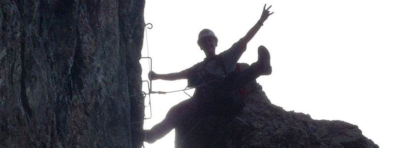
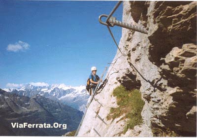
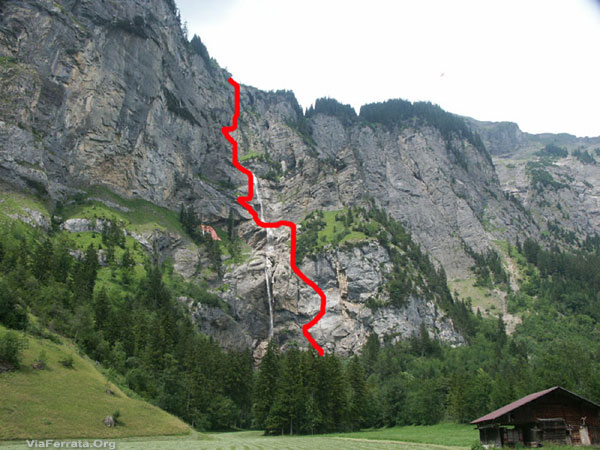
Via Ferrata
La ferrata commence par une échelle très raide qui conduit à une vire plane aérienne. Tu la suis à droite jusqu'à ce que l'équipement de sécurité indique à nouveau l'ascension.
La viaferrata prend de plus en plus d'altitude par des marches dans la roche, des dévers herbeux et des vires étroites ; banc en bois accueillant à un tiers de la via ferrata.
Suit une traversée assez exposée avant que la voie prenne la direction d'une vire en terrasse sur la partie supérieure de la paroi. Trois échelles verticales décalées gravissent ensuite sans problème un dièdre abrupt. Reste bien concentré quand tu passes d'une échelle à l'autre… coups de cœur garantis…
Une autre échelle métallique débouche de biais sur une vire herbeuse ascendante. Pour finir, on escalade l'arête par un éboulement jusqu'à la sortie.
Signe le livre d'or qui se situe dans la grotte.
Retour
Suivre le balisage blanc et bleu jusqu'à un petit cirque rocheux (névés fréquents en début d'été). Attention quelques névés pentus peuvent être glacés.
Compte un bonne heure, puis un sentier plus où moins à plat vers le SO durant une autre bonne heure avec la remontée vers le col du Satteli (2119m). Finalement redescendre vers la Tallihutte en 45 min.
Poursuivre par la droite jusqu'au lac d'Engstlen (1850 m) et l'alpage (Engstlenalp, 1834 m).
 Où dormir
Refuge de Tällihutte, 20 places ouvert de la mi juin à fin octobre.
Compte env. Frs. 20.-- par personne, Tél 033 975 14 10. Hors de Suisse ++ 41 33 975 14 10
Photos & Media
par Hans Howald, Youtube -
-
508e Via Ferrata de Talli, Meiringen, Bern, Switzerland
Via Ferrata Tälli, Meiringen, Bern
Footbridge Monkey Bridge Ladders Zipline 0 0 5 0 Features
Takes two days, the approach is a bit long, but of mid-range difficulty. The via has several vertiginous sections.
ViaFerrata Tips and TricksTake the map of the area and all the gear you need to spend two long days in the mountains.
Only go if the weather is good and stable because there are no way outs. At the beginning of the summer snowfields remain at the start, on the ledges at higher altitudes and on the return path of the north face (equip yourself with crampons and an ice-axe if needed- but you must know how to use them).
Reserve a place at the hut before leaving.
Grade
Strength 4 Dizziness 4 Type High-Mountain: 2 Technics 2 Evaluation Very Difficult Information
Length and Altitude1'500 m elevation gain, 600 m of which is the ferrata
Start of the via: 2'067 m
Time of Year
July to early October
Timing
1st day: 550 m of elevation gain: 2h00 of walking
2nd day: 1'000 m of elevation gain, 600 m of which is the via. This should total to 6 h.By CarLyon-Geneva, A 40; Geneva-Lausanne N1, in Vevey go towards Bern, Basel/Bâle N12;
->In Bern, take N6 towards Interlaken,
-> in Interlaken go towards Méringen-Furen.By TrainBy bus from Meiringen to Gadmen. Contact the SBB for schedules and fares.
AccessFrom Furen (1149m) on the road from the bottom station of the Tälli lifts (1171 m) to the Tälli restaurant; there is no official bus stop.
Information from the electric power plant in Innertkirchen, tel. 033 982 20 60.
On foot, briefly follow the trail to access the Birchlaui pasture (1,597m) by going up the sparsly forested slope to the Tälli restaurant (1,716m). Take the sidelong uphill by following the white and blue markings under the steep walls of the Tällistock until you reach the start of the Alpligerstock via (2,067m).
Via Ferrata
The ferrata starts with a very steep ladder that leads to a flat vertiginous ledge. Follow it towards the right until the security equipment indicates a new ascent.
The via ferrata gains more and more altitude with some steps in the rock, grassy overhangs, and narrow ledges; there is a welcoming bench one third of the way up the via ferrata.
Follow a fairly exposed traverse before taking the path that leads to a kind of terace ledge on the upper part of the rock wall. Three staggered vertical ladders allow you to easily climb an abrupt dihedral. Stay focused when you go from one ladder to the next...your heart will skip a beat!
Another metallic ladder leads sideways to an ascending grassy ledge. To finish, we climb the ridge via a landslide to the exit.
Sign the golden book that is found in the cave.
Way Back
Follow the white and blue markings to a rocky cirque (snowfields often remain here at the beginning of summer). Be careful as some of the steeper snowfields can be icy.
It will take a good hour, then, take a more or less flat path heading SW for another good hour, which includes the way back up towards the Satteli pass (2119m).
Lastly go back down towards the Tallihutte in about 45 min.Where to SleepRefuge de Tällihutte, 20 spots available, open from mid-June to end of October.
Account for about 20.-- Frs. per person, Tel. 033 975 14 10. If calling from outside of Switzerland ++ 41 33 975 14 10
Media
by Hans Howald, Youtube -
-
519e Via Ferrata Allmenalp, Kandersteg, Bern, Switzerland
Via Ferrata Allmenalp, Kandersteg, Bern
Footbridges Monkey Bridge Ladders Ziplines 2 30 m 4 2 Features
Not for everyone. Very technical.
There are stakes instead of the traditional metal steps. Lots of contact with the rock. The stakes can present a certain risk. Be very careful if you want to bring children.
ViaFerrata Tips and TricksPay attention to the weather! It changes very quickly in Kandersteg. If rain is imminent, don't go. The stream can swell very quickly and you will be stuck in the via! We once stayed 2 hours waiting for a thunderstorm to pass and there were many falling rocks.
Hiking shoes with an excellent sole are mandatory!
Grade
Strength 4 Dizziness 4 Type High-Mountain: 3 Technics 3 Evaluation Extreme Information
Office du TourismeKandersteg
Length and AltitudeAltitude gain: 350 m
Start altitude: 1'176 m
Time of Year
June to October (when the lifts are open)
Timing
Approach: 20 minutes
Via Ferrata: 3h00
Way back: with the lifts or 2h on foot.By CarGo past Bern and continue towards Thun. Then go up towards Kandersteg.
By TrainGo to Thun and then take the bus. Contact the SBB for schedules and fares.
AccessFrom the Kandersteg train station take the hiking trail that goes towards the valley. Where the Allmibach flows into the Kander, head north to the right of the stream until you get to the starting point at about 1250 m.
From the lower lift station of the Allmenalp, after a farm, cross the river on a bridge.
From the bottom of the lifts, follow the blue and white trail (Klettersteig). Parking is free.
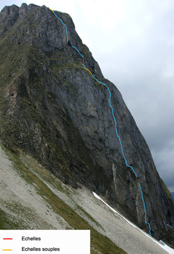
Via Ferrata
The route follows the Allmibach waterfall and the scene is very romantic. Everything starts off with three ladders and a vertiginous climb. Instead of going up traditional steps, you climb on stakes.
It's pretty different from the usual via ferratas and a bit awkward. It's slippery and you must have adequate footwear (tennis shoes and flip flops are prohibited).
You cross over the waterfall via a long footbridge. Here, a path takes you to the next section.
A twisting ladder will make you rotate 180 degrees and you will gain a new perspective on the waterfall. It's very vertiginous, but you remain in contact with the rock along a ridge.
If you are with a guide you can go on the zipline (it is locked, hence, you must have a guide)
You keep climbing and traverse a wooden footbridge and you then have the choice between a zipline or a very vertiginous rope bridge! Going up to the zipline in wet weather is a real challenge. The steps that were put in place have no profile, they are real soapstones. Be careful!
Crossing the monkey bridge is moment of pure intensity! The last part overlooks the entire via and is easier.
Way Back
If you make it before 18h00, the lifts are still open. The restaurant next to the lifts is really nice and the pies are excellent.
If you arrive after 18h00, be prepared for 2 hours of not always well-marked downhill. To get back to the resort, follow the road for 30 minutes and then the yellow signs. If you get lost, tell yourself that you are neither the first nor the last!
Where to Spend the NightCheck with the Tourism Office. Interlaken is really nice and there are several campgrounds.
par Josh Turner Youtube
Media
-
-
524e Via Ferrata Gantrisch, Gurnigel Park, Bern, Switzerland
Via Ferrata Gantrisch, Gantrisch Park, Gurnigel, Bern
Footbridge Monkey Bridge Ladders Zipline 0 0 2 x soft ladders
1 x standard0 Features
This via ferrata is equipped with rungs and stakes/nails. Not always very nice.
No escape routes. If you start, you finish!
ViaFerrata Tips and TricksIt's possible to rent equipment from the Gurnigel hut.
This region is full of hikers. Leave early if you want peace.
Grade
Strength 3 Dizziness 4 Type High Mountain: 2 Technics 1 Evaluation Difficult
Information
Office du Tourisme du Lac Noir
Length and AltitudeStart:
End: 2'175 m.
Altitude gain: 340 m.
GPS Coordinates
46.706079158789045,
7.455211373948051Time of Year
From mid-June to end of October (snow)
Horaire
Approach: 45 min
Via Ferrata: 2h
Way back: 45 min
Total: 3h30 - 4hBy CarIt's a bit of a mess to get to this via ferrata but the car seems to be the most reliable option.
Go to the Wasserscheide parking
By TrainContact the SBB.
AccessLook for the via ferrata via the trail that leads to the Leiterepass. You will get to the base of the cliff and from here you can see the via ferrata scrambling up the wall.
Via Ferrata
This via ferrata goes up rather steeply and you will discover some sections that are fairly demanding for your arms. But it's doable and the void envelops you. From the top you can see the starting point, imagine the presence of the void!
The climb to the top of the Gantrisch ends with several grassy sections.
Way Back
You can go towards the Leiterpass on the alpine (as it is designated) trail.
Where to Spend the NightCheck with the Tourism Office.
par m raegi Youtube
Media
-


